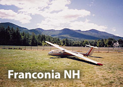
1B5 - Franconia Airport
Lat/Long: 44-11-45.229N / 071-44-58.310W
(44.1958969 / -71.7495306) (estimated)
Elevation: 970 ft. / 296 m (estimated)
Variation: 16W (1985)
From city: 2 miles S of FRANCONIA, NH
Sectional chart: MONTREAL
CTAF: 122.8
UNICOM: 122.8
WX ASOS at HIE (14 nm NE): 118.525 (603-837-2769)
The club traditionally operates from Franconia airport in the White Mountains of New Hampshire (about 2 hours drive north), for ridge and mountain soaring for the two weekends and week around Labor Day, often the peak of the fall foliage season. Many of our members bring their families for a weekend or more of soaring, hiking, camping, and other activities.
BLIPMAPS!