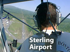
3B3 - Sterling Airport
Lat/Long: 42-25-30.329N / 071-47-28.258W
(42.4250914 / -71.7911828)
Elevation: 459 ft. / 140 m (estimated)
Variation: 15W (1985)
From city: 2 miles SW of STERLING, MA
Sectional chart: NEW YORK
CTAF: 122.9
WX ASOS at FIT (8 nm N): 135.175 (978-343-9121)
WX ASOS at ORH (10 nm S): PHONE 508-795-7546
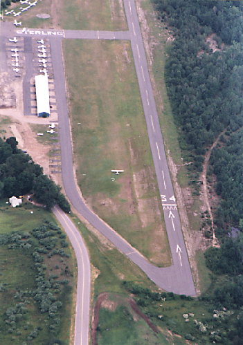
The club operates at an airport outside the small town of Sterling, about 40 air miles west of Boston's Logan airport, in a beautiful rural area. The field is 460 feet above sea level. Two excellent 3000 foot runways are available, one asphalt and the other grass. They are oriented (340) for perfect headwinds on good soaring days. We share Sterling Airport with some general aviators who fly some fascinating old and new aircraft.
Soarable conditions occur at Sterling over 100 days per year. Average soarable conditions include convection (thermals), varying from 5000 to 10,000 feet in height and 2 to 10 knots in strength depending on the season. We also have an occasionally soarable wave when the air is stable and the winds aloft are strong.
In our B-4s or their own fiberglass gliders, club members regularly use local convection and wave for cross-country flights of up to 8 hours covering hundreds of miles.
Even when conditions are not soarable, they are often flyable; our student pilots often use "stable" days to try new gliders or work on technique.
Driving times to Sterling are about 1 hour from Boston, 45 minutes from Nashua NH, and 15 minutes from Worcester.
From Boston:
Take Route 2 West to I-190 in Leominster. Go South on I-190 (There will be a ramp down off Rt 2 onto Mechanic Street then take another right onto the ramp up to I-190). Follow I-190 south to Exit 5. After exiting, drive north (toward Mt. Wachusett) about a mile on Massachusetts 140. Turn right on Crowley Road (a green and white airport sign marks the intersection). Drive about a mile to the end of Crowley Road until your reach the airport.
From CT:
Take Rt 84 north to Mass Pike east. Get off at Millbury or Auburn and get onto I-290 East heading into Worcester. Take dual exit 19-20 following exit 20 to get to I-190 North. Follow I-190 north to Exit 5. After exiting, drive north (toward Mt. Wachusett) about a mile on Massachusetts 140. Turn right on Crowley Road (a green and white airport sign marks the intersection). Drive about a mile to the end of Crowley Road until you reach the airport. .
At the Airport:
Drive up to the Main Building to park and walk south--towards the highway--to the green GBSC clubhouse (shed) that is beyond the blue hangar sheds (walk back toward the highway). Once you are at the shed you will see picnic tables and probably the GBSC sign-in table. The Senior Field Officer will be at or near that table. If no one is in the immediate vicinity, ask someone where the GBSC Senior Field Officer is. Depending on the wind direction, we may be at the other end of the field. If so, walk to that end of the field keeping close to the edge. Do NOT under any circumstances, go near or cross the taxiway, and be alert to moving aircraft and ground vehicles.
See how Sterling Airport looks during the Sterling Fair
Website Design and Graphics by Kiirja Paananen
Webmaster: Glen Kelley
All materials Copyright 2005 by Greater Boston Soaring Club. All Rights Reserved.